
ASSESSING DROUGHT IMPACTS IN ERBIL, IRAQI KURDISTAN: A STUDY OF LAND SURFACE TEMPERATURE AND VEGETATION HEALTH INDEX USING LANDSAT TIME-SERIES

Article Sidebar
-
Erbil, Drought, Crops Yield, LST, VHI, Landsat Time Series
Abstract
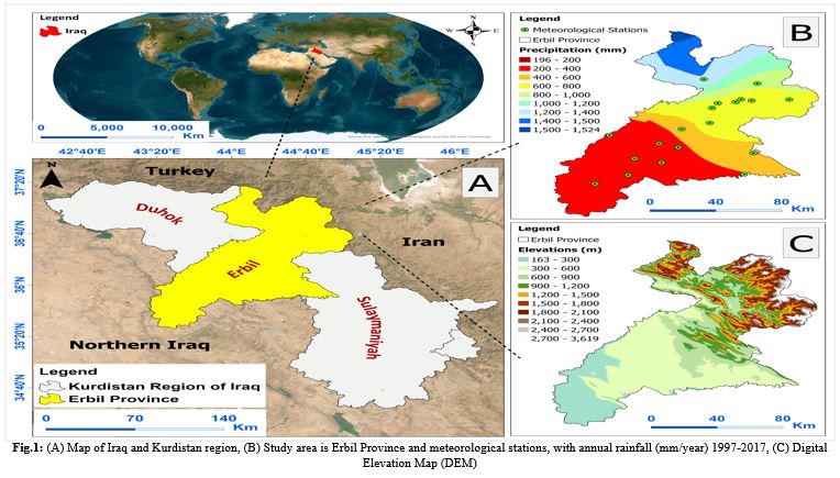
Drought is a natural disaster that has severe implications for various aspects of society, including the economy, agriculture, environment, and community. The study conducted in the Erbil province, Kurdistan Region, Iraq from 1998 to 2017 aims to determine the frequency and intensity of drought, highlighting its diverse effects on society, encompassing the economy, agriculture, environment, and local community. Indicators, for instance, the Land Surface Temperature (LST) obtained from satellite data (Landsat) and the Vegetation Health Index (VHI), were employed to evaluate the severity of droughts. The outcomes indicated that Erbil encountered severe droughts in 1999, 2000, and 2008, which resulted in a significant decrease in crop outcomes. Additionally, 2008 was marked by escalating drought conditions, as measured by VHI values exceeding 40; as a result, the percentages reached (86.5%, 67.6%, and 53.7%), respectively. Significant relationships were revealed, with a confidence level of 0.9, between VHI and various factors such as precipitation, LST, and crop yield, with corresponding degrees of (-0.612, 0.615, 0.613, and 0.635). The study also disclosed that alterations and decreases in precipitation occur as the growing season progresses, whereas the following years (2000, 2008, and 2012) saw a pronounced decline in yield, failing to meet the lower limit of water demands for crops. Moreover, the most affected locations in Erbil Province were found to be in the central and southwestern parts of the province.
Full text article
References
Al-Quraishi, A. M. F., Qader, S. H., & Wu, W. (2020). Drought monitoring using spectral and meteorological based indices combination: a case study in Sulaimaniyah, Kurdistan region of Iraq. Environmental remote sensing and GIS in Iraq, 377-393. http://dx.doi.org/10.1007/978-3-030-21344-2_15
Almamalachy, Y. S., Al-Quraishi, A. M. F., & Moradkhani, H. (2020). Agricultural drought monitoring over Iraq utilizing MODIS products. Environmental remote sensing and GIS in Iraq, 253-278. http://dx.doi.org/10.1007/978-3-030-21344-2_11
Bhuiyan, C. (2004). Various drought indices for monitoring drought condition in Aravalli terrain of India. Proceedings of the XXth ISPRS Congress, Istanbul, Turkey. http://dx.doi.org/10.1016/j.jag.2006.03.002
Bhuiyan, C., Singh, R., & Kogan, F. (2006). Monitoring drought dynamics in the Aravalli region (India) using different indices based on ground and remote sensing data. International Journal of Applied Earth Observation and Geoinformation, 8(4), 289-302. https://doi.org/10.1016/j.jag.2006.03.002
Busetto, L., Colombo, R., Migliavacca, M., Cremonese, E., Meroni, M., Galvagno, M., Rossini, M., Siniscalco, C., Morra Di Cella, U., & Pari, E. (2010). Remote sensing of larch phenological cycle and analysis of relationships with climate in the Alpine region. Global change biology, 16(9), 2504-2517. https://doi.org/10.1111/j.1365-2486.2010.02189.x
Carlson, T. N., Perry, E. M., & Schmugge, T. J. (1990). Remote estimation of soil moisture availability and fractional vegetation cover for agricultural fields. Agricultural and Forest Meteorology, 52(1-2), 45-69. https://doi.org/10.1016/0168-1923(90)90100-K
Dash, P., Göttsche, F.-M., Olesen, F.-S., & Fischer, H. (2002). Land surface temperature and emissivity estimation from passive sensor data: Theory and practice-current trends. International Journal of Remote Sensing, 23(13), 2563-2594. https://doi.org/10.1080/01431160110115041
Du, L., Tian, Q., Yu, T., Meng, Q., Jancso, T., Udvardy, P., & Huang, Y. (2013). A comprehensive drought monitoring method integrating MODIS and TRMM data. International Journal of Applied Earth Observation and Geoinformation, 23, 245-253. https://doi.org/10.1016/j.jag.2012.09.010
Fadhil, A. M. (2011). Drought mapping using Geoinformation technology for some sites in the Iraqi Kurdistan region. International Journal of Digital Earth, 4(3), 239-257. https://doi.org/10.1080/17538947.2010.489971
Gaznayee, H. (2020). Modeling Spatio-Temporal Pattern of Drought Severity Using Meteorological Data and Geoinformatics Techniques for the Kurdistan Region of Iraq Agriculture Science (Application of GIS and Remote Sensing in Drought) Salahaddin University-Erbil Sulaimani, Iraq]. http://dx.doi.org/10.13140/RG.2.2.17234.30402
Gaznayee, H. A., & Al-Quraishi, A. M. F. (2019). Analysis of agricultural drought's severity and impacts in Erbil Province, the Iraqi Kurdistan region based on time series NDVI and TCI indices for 1998 through 2017. Jour of Adv Research in Dynamical & Control Systems, 11(11), 287-297. https://doi.org/10.5373/JARDCS/V11I11/20193198
Gaznayee, H. A. A., & Al-Quraishi, A. M. F. (2019). Analysis of agricultural drought, rainfall, and crop yield relationships in Erbil Province, the Kurdistan region of Iraq based on Landsat time-series MSAVI2. J. Adv. Res. Dyn. Control Syst, 11(12), 536-545. https://doi.org/10.5373/JARDCS/V11SP12/20193249
Gaznayee, H. A. A., Al-Quraishi, A. M. F., Mahdi, K., & Ritsema, C. (2022). A geospatial approach for analysis of drought impacts on vegetation cover and land surface temperature in the Kurdistan Region of Iraq. Water, 14(6), 927. https://doi.org/10.3390/w14060927
Guo, X., Zhang, H., Wu, Z., Zhao, J., & Zhang, Z. (2017). Comparison and evaluation of annual NDVI time series in China derived from the NOAA AVHRR LTDR and Terra MODIS MOD13C1 products. Sensors, 17(6), 1298. https://doi.org/10.3390/s17061298
Hameed, H. (2013). Water harvesting in Erbil Governorate, Kurdistan region, Iraq: detection of suitable sites using geographic information system and remote sensing. Student thesis series INES. http://lup.lub.lu.se/student-papers/record/3737025
Ibrahim, H. S. (2024). Analysis of Monthly Global Solar Radiation in Erbil-Iraq. Science Journal of University of Zakho, 12(3), 361-366. https://doi.org/10.25271/sjuoz.2024.12.3.1312 https://doi.org/10.25271/sjuoz.2024.12.3.1312
HS, R. M. (2009). Drought climatology of Indo-Gangetic region of India using remote sensing and crop growth simulation models. http://hdl.handle.net/10603/6265
Jiao, W., Zhang, L., Chang, Q., Fu, D., Cen, Y., & Tong, Q. (2016). Evaluating an enhanced vegetation condition index (VCI) based on VIUPD for drought monitoring in the continental United States. Remote Sensing, 8(3), 224. https://doi.org/10.3390/rs8030224
Karim, T. H., Keya, D. R., & Amin, Z. A. (2018). Temporal and spatial variations in annual rainfall distribution in Erbil province. Outlook on Agriculture, 47(1), 59-67. https://doi.org/10.1177/0030727018762968
Kogan, F., Stark, R., Gitelson, A., Jargalsaikhan, L., Dugrajav, C., Tsooj, S. (2004). Derivation of pasture biomass in Mongolia from AVHRR-based vegetation health indices. Int. J. Remote Sens.25,2889-2896. https://doi.org/10.1080/01431160410001697619
Kogan, F. N. (1986). Climate constraints and trends in global grain production. Agricultural and Forest Meteorology, 37(2), 89-107. https://doi.org/10.1016/0168-1923(86)90001-8
Kogan, F. N. (1990). Remote sensing of weather impacts on vegetation in non-homogeneous areas. Int. J. Remote Sens. 11,1405-1419. https://doi.org/10.1080/01431169008955102
Leal Filho, W. (2011). Experiences of climate change adaptation in Africa. Springer. https://doi.org/10.1007/978-3-642-22315-0
Lee, S.-H., Yoo, S.-H., Choi, J.-Y., & Bae, S. (2017). Assessment of the impact of climate change on drought characteristics in the Hwanghae Plain, North Korea using time series SPI and SPEI: 1981-2100. Water, 9(8), 579. https://doi.org/10.3390/w9080579
Mikail, A. Q., & Hamad, R. (2023). Mapping Flood Vulnerability by Applying EBF And AHP Methods, in the Iraqi Mountain Region. Science Journal of University of Zakho, 11(1), 1-10. https://doi.org/10.25271/sjuoz.2023.11.1.1033
Park, H., Kim, K., & Lee, D. K. (2019). Prediction of severe drought area based on random forest: Using satellite image and topography data. Water, 11(4), 705. https://doi.org/10.3390/w11040705
Pei, F., Wu, C., Liu, X., Li, X., Yang, K., Zhou, Y., Wang, K., Xu, L., & Xia, G. (2018). Monitoring the vegetation activity in China using vegetation health indices. Agricultural and Forest Meteorology, 248, 215-227. https://doi.org/10.1016/j.agrformet.2017.10.001
Qu, C., Hao, X., & Qu, J. J. (2019). Monitoring extreme agricultural drought over the Horn of Africa (HOA) using remote sensing measurements. Remote Sensing, 11(8), 902. https://doi.org/10.3390/rs11080902
Razvanchy, H. A. S. (2008). Modelling some of the soil properties in the Iraqi Kurdistan Region using Landsat datasets and spectroradiometer (Doctoral dissertation). Cranfield University, Cranfield, UK. http://dx.doi.org/10.5194/isprs-archives-XLII-2-W16-21-2019
Saeed, M. A., & Abas, K. (2012). Analysis of Climate and Drought Conditions in the Federal region of Kurdistan. International Scientific Journal Environmental Science,2. https://doi.org/10.1007/s12205-021-2046-x
Sahoo, R., Dutta, D., Khanna, M., Kumar, N., & Bandyopadhyay, S. (2015). Drought assessment in the Dhar and Mewat Districts of India using meteorological, hydrological and remote-sensing derived indices. Natural Hazards, 77, 733-751. https://doi.org/10.1007/s11069-015-1623-z
Sholihah, R. I., Trisasongko, B. H., Shiddiq, D., La Ode, S. I., Kusdaryanto, S., & Panuju, D. R. (2016). Identification of agricultural drought extent based on vegetation health indices of landsat data: case of Subang and Karawang, Indonesia. Procedia Environmental Sciences, 33, 14-20. https://doi.org/10.1016/j.proenv.2016.03.051
Song, C., Yue, C., Zhang, W., Zhang, D., Hong, Z., & Meng, L. (2019). A remote sensing-based method for drought monitoring using the similarity between drought eigenvectors. International Journal of Remote Sensing, 40(23), 8838-8856. https://doi.org/10.1080/01431161.2019.1624860
Sun, D., & Kafatos, M. (2007). Note on the NDVI‐LST relationship and the use of temperature‐related drought indices over North America. Geophysical research letters, 34(24). https://doi.org/10.1029/2007GL031485
Sutcliffe, J. V. (2012). Hydrology: A Question of Balance. Int. Water Manag. Institute, Colombo, Sri Lanka, Spons. this Publ. 29-30. https://www.amazon.com/Hydrology-Question-Balance-Proceedings-Reports/dp/1901502775
UNESCO. (2009). Survey of Infiltration Karez in Northern Iraq: History and Current Status of Underground Aqueducts A report prepared for UNESCO 56. https://unesdoc.unesco.org/ark:/48223/pf0000185057
UNISCO. (2014). Integrated drought risk management- DRM executive. Natl. Framew. IRAQ AN Anal. Rep. MARcH Second edi. https://unesdoc.unesco.org/ark:/48223/pf0000228343
USAID, I. (2008). Kurdistan Region: Economic Development Assessment. In: United States Agency for International Development Washington, DC. https://www.usaid.gov/iraq
Vogt, J. V., Viau, A. A., Beaudin, I., Niemeyer, S., & Somma, F. (1998). Drought monitoring from space using empirical indices and physical indicators. Proc. Int. Symp. on Satellite-Based Observation: A Tool for the Study of the Mediterranean Basin, Tunis, Tunisia. http://dx.doi.org/10.1007/978-94-015-9472-1_13
Walther, C. (2011). Managing Change in the Marshlands: Iraq's Critical Challenge. United Nations Integrated Water Task Force for Iraq, United Nations: Iraq. https://doi.org/10.1063/5.0033124
Wan, Z., Wang, P., & Li, X. (2004). Using MODIS land surface temperature and normalized difference vegetation index products for monitoring drought in the southern Great Plains, USA. International Journal of Remote Sensing, 25(1), 61-72. https://doi.org/10.1080/0143116031000115328
Wang, H., Chen, Y., Pan, Y., & Li, W. (2015). Spatial and temporal variability of drought in the arid region of China and its relationships to teleconnection indices. Journal of hydrology, 523, 283-296. https://doi.org/10.1016/j.jhydrol.2015.01.055
Wilhite, D. A., Pulwarty, R.S. (2018). Drought and Water Crises, Drought and Water Crises. https://doi.org/10.1201/9781315265551
Zhang, Y., Jin, J., Jiang, S., Ning, S., Zhou, Y., & Wu, Z. (2019). Quantitative assessment model for the effects of drought mitigation on regional agriculture based on an expectation index of drought mitigation effects. Water, 11(3), 464. https://doi.org/10.3390/w11030464
Authors
Copyright (c) 2025 Ragheb K. Mohammad, Sara H. Zaki , Heman A. Ahmed Gaznayee, Halmat A. Sabr , Payman H. Aliehsan, , Sherwan Y. Hammad, Snoor H. Ababakr , Hawar A. Razvanchy, and Kawa K. Hakzi

This work is licensed under a Creative Commons Attribution 4.0 International License.
Authors who publish with this journal agree to the following terms:
- Authors retain copyright and grant the journal right of first publication with the work simultaneously licensed under a Creative Commons Attribution License [CC BY-NC-SA 4.0] that allows others to share the work with an acknowledgment of the work's authorship and initial publication in this journal.
- Authors are able to enter into separate, additional contractual arrangements for the non-exclusive distribution of the journal's published version of the work, with an acknowledgment of its initial publication in this journal.
- Authors are permitted and encouraged to post their work online.